|
|
|
|
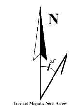
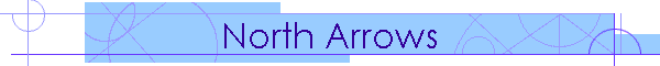
The north arrow is an integral part of the map. Its primary function is to convey information regarding the orientation of the map, but it is also used as a decorative feature and many cartographers spend some time designing unique and creative ways to "dress up" the north arrow. It should not, however, be so prominent as to distract from the map itself. There are two ways to show map orientation: magnetic north and true north. Magnetic north refers to the direction a compass will point, also known as the "magnetic pole". However, the true north pole and the magnetic pole are not the same and so a correction, known as declination, must be applied to the compass reading to obtain true north. The corrections vary according to region and also change over time. This is why it is especially important to show the survey date on the map if only magnetic north is shown. The National Geophysical Data Center tracks the changes and there is a handy calculator available on-line. There is a link under the Links section on this site. In peninsular Florida, declination is around 4 degrees west, meaning that a compass will point four degrees west of true north. Therefore the declination must be added to the actual compass reading to obtain true north. As you cross the Panhandle of Florida, the declination decreases to zero near Pensacola, and then becomes increasingly easterly as you continue across the United States. An east declination indicates the compass points east of true north and the declination is subtracted from the compass bearing. The style of north arrow used indicates if true north or magnetic north is indicated. The arrow on the left indicates true north by using a full barb. The middle arrow shows magnetic north using a half barb, and the third arrow indicates both directions and states the amount of declination. In general, it is best to indicate both directions.
|